Friday, November 15, 2019

Newsletter No. 22---The Oil Patch

After full immersion in a visit to the cotton patch in late August, we needed a coffee break. Wanting to try a new spot in Lockhart we went south on Highway 86 in the direction of Luling looking for an alternative. We’ve found that some gasoline stations have gone to higher grade coffee and so we stopped at a Chevron station to check it out. When we walked into the station, we spotted the coffee bar and also noted that there were two small tables, each with two chairs. One of the two tables was occupied by a man about 55 years old. He seemed talkative and when we mentioned that Exxon was part of our life for many years, he said “oh, from the oil patch”. Had we not gone to that station at that time and struck up this conversation, we would not have heard the old timey phrase “oil patch”.

One never knows where the next interesting bit of information will show up. We talked with this fellow, Bud, for what seemed like two hours and covered many topics of mutual interest. Bud is a self-employed contractor in the business of oil well reworking. He rehabilitates old oil wells that decline in production rate and can be made to produce a few more barrels per day and he has done a lot of that kind of work. It turns out that his wife Kathy is the manager at this convenience store so we met her too. We learned that Bud does a lot more with his oilfield skills than just rework old wells. They told of a three-month job he once had designing and building the smokestack gas scrubbing equipment for a Black’s Barbeque restaurant in Austin. It happened that Black’s built their BBQ joint in a populated area of Austin. This was not appreciated by the folks downwind of the smokestack. So, he was hired to take care of it.
Bud and his wife once lived in Wimberley where his family had roots that went back a hundred years. He knew all the old timers that we were able to recall to him. They decided about ten years ago to move to Lockhart where they would be closer to his work.
The term oil patch once was a common, heavily used term for defining the local oil industry; more specifically the exploration and production of petroleum. The term was first used in about 1952 and became popular among those who worked the drilling rigs. The year 1952 was long before the sophistication of drilling techniques such as horizontal drilling, fracking, and deep well production. Fracking, by the way sounds new from all the controversy surrounding it but has been around since the 1970s. Eagle Ford drilling made it more newsworthy. From a folklore standpoint, the term oil patch generates a mental image in our minds of oil production areas that have low producing wells, probably shallow, drilled close together. The pump jacks are small for the shallow wells and increase in size as the wells run deeper. Having just finished cotton production, we recalled the term cotton patch as symbolizing hard working people harvesting cotton. Perhaps that might have some connection to the origin of the term oil patch here in Texas. There is also the term watermelon patch, so the assumption is that the term originates from agriculturally based people now working in the oil field. In fact, a search on the web corroborates that the term oil patch is local to Texas and Oklahoma and is derived from an association with the oil fields that sprung up in the farming country.
Figure 1 Oil Fields in Guadalupe County
 Just to the east of us in Guadalupe and Caldwell Counties, in an area centered on Luling and reaching as far north as Prairie Lea and Stairtown, is an area that fits the stereotype of an oil patch. So, we thought we would check it out and see if any oil is still being produced there. The oil patch of Guadalupe and Caldwell Counties starts southwest of Luling, crosses IH-10 and extends just past Prairie Lea. This string of oil fields runs in the northeast direction, parallel to the Balcones Escarpment. All the oil is at a depth of about 2800 feet in the Austin Chalk formation. Geologists tell us that the oil was not formed in the chalk layer but migrated upward from the underlying shale formations due to saltwater pressure from below. Knowledge of these areas was deduced from observation of the surface geology and the seepage of oil into fault lines on the banks of the San Marcos River.  Residents also noticed an oily residue in water from domestic wells. That was in 1903. So, it took nearly 20 years to get to the first producing well.
The commercial reality of oil in the area of Luling began in 1922 when wildcatter Edgar Davis was drilling several wells in the area looking for signs of oil. Davis was a very interesting fellow. He was born in Massachusetts in 1873, had only a high school education and by 1905 was making his first million there in the shoe business. Later he added around three million dollars to that with his early investments in foreign rubber plantations and as the largest individual stockholder in the United States Rubber Company. He sold his holdings after thirteen years and gave much of the proceeds away to friends and New York associates. Then in 1919 he fulfilled the request of his brother Oscar to manage his share of the oil leases he had purchased in Caldwell, County, Texas. A very religious man, after assessing the situation, Edgar believed it was his mission to improve the local economy by diversification. He believed he could do that by producing oil. In 1921 he incorporated the United North and South Oil Company and after his brother died purchased Oscar’s oil leases from his estate. He had drilled six dry wells near Stairtown and was heavily in debt when Rafael Rios No. 1 (the seventh well) at a depth of 2400 feet “gushed in on August 9, 1922.”. To this date, the well and its enhancements have produced more than 135 million barrels of oil. Davis sold the properties in the area in 1926 to Magnolia Petroleum Company, which was later bought by Mobil Oil Co.
Davis was a great benefactor to the community of Luling, establishing the Luling Foundation for the teaching of improved agricultural methods. He also provided public improvements such as a golf course, various other facilities and endowments for each. He never married and is buried on the site of one of his former homes in Luling where the Edgar B. Davis Memorial Hospital was built in 1966.
Davis certainly was an entrepreneurial type but he didn’t start drilling in this area out of chance, because there were other oil explorers who had information that there was oil in the area. The archives in Luling have a copy of a map hand drawn by Thomas Wilson indicating oil fields to the immediate east of Luling. Despite the difficulty to read it, here is a copy of the map.

 Figure 2 Luling Oil Company map 1903. 


The wide band at the top of the map is the railroad, and below that is US90. The city of Luling is to the left. And, of course, the Rios No. 1 well is to the north of all of this up by Hwy 80 at Stairtown. Over the many years since 1925 the whole area from Stairtown to south of Luling was filled in with wells---many wells. The graph below shows more recent information on 305 Leases, 52 Producing Operators and 4,835 Drilled Wells.
Figure 3 Oil Production Record in Guadalupe County


Oil production went from 1 M barrels in 1994 to less than 500K barrels in 2019; gas production went from 800K MCF in 1994 to almost nothing in 2019.
There was, and still is in some places, a sulfurous odor in the area.  That odor is due to hydrocarbon sulfides leaking from the wells of the area. We were reminded of this odor having come across an archival article in the Luling Library titled ‘Taking the Stink Out’ by Bob Banta. Banta, writing for the Austin American Statesman, was reporting on a TV commercial being made by the Phillips Company’s ad agency starring Ben Rollert, an independent oil operator. A video, made in 1981 on a 320- acre cattle and horse ranch between San Marcos and Luling, animals could be seen grazing peacefully among 80 producing oil wells. The ad touted Phillips’ work in cleaning up the pervasive smell of sulfurous natural gas near Luling. Because of the company’s expertise in gas gathering, they had built a huge gathering plant 5-6 years before that sucked the gas from wells into underground lines that piped it to Houston as fuel. Unfortunately, at this time we could find no pictures or other information on the plant.
On a previous research trip to the Luling Library we had purchased a copy of Vol. 16, No. 2 of the Fall 1998 issue of the Plum Creek Almanac which included a map and article of the Gander Slough Oil Field adjacent to Stairtown. And on October 22 with the following map we headed out to see what we could find.


Figure 4 Oil field map of Gander Slough 

We entered the area from SH 80 turning to the southwest on 671 at Stairtown which was marked Oil Field Rd. You can see that this map has many identifying  numbers representing homes, businesses and a church and school back in the 1920s when most of the oil activity was going on in the area. We passed many pumps still working and others that had been idled. When we got to Jones Rd. we turned left and followed the box around back to where we had started. To our right was the part of Gander Slough that had been the main drag with homes, a filling station and store and the Baptist Church. Now the road was gravel with a gate which was open and one current residence was on the right. It wasn’t very welcoming, but we decided to nose in anyway and see if there were any old foundations we could see. There was nothing but short roads leading off to storage tanks in the woods. AND… at one of them was an Enterprise Petroleum truck pulled in filling up. R got out of the car to talk to the driver and I could see that they were having quite an animated conversation about the picture R was showing him in the in the Plum Creel history book of what a busy place the area had been in the old days. Deano, the driver, was so intensely interested in the history of Gander Slough that we left the book with him and picked up another for a dollar at the library later that day.  Deano volunteered the information that his was only one of 4 trucks that stopped there daily, and each loaded 162 barrels of oil.
Figure 5 Enterprise truck filling up at the tank farm.


 Figure 6 From  Parson's book Images of America LULING. 


Figure 6 shows what the the Gander Slough oil field looked like when drilling activity was at a peak level.

 Figure 7 In the early days of Gander Slough 

This photo was taken on the eastern end of the Luling oil field where the rougher element spent their leisure time.


Figure 8 Brass knuckles carried by Robert Carter  to keep the peace.


 According to the Texas State Historical Association the name Gander Slough shows up also as Gander Slue and Gander Slu; the latter spelling was suggested by an oilfield worker as a take off on the Goose Creek oilfield near Baytown, Texas.  This is where Humble, now ExxonMobil, constructed its major oil refinery in 1921 adjacent to the field and named the plant and townsite Baytown. The Dayton-Goose Creek Railroad Co. built in 1918 connected the refinery to the Goose Creek field.

Along with Gander Slough, nearby Sullivan, Texas is another ghost town. Just off highway 90 it was 3 miles west of Luling and 15 miles northeast of Seguin. Its importance began as a railroad switch around 1876 when the Galveston, Harrisburg and San Antonio Railroad crossed Caldwell and Guadalupe Counties on its way to San Antonio. The town is believed to be named for John Sullivan, the engineer on the first passenger train in 1877. When oil was discovered in Gander Slough in 1922 the railroad switch was already in place for tank cars to be dropped off and loaded. A tank farm was built and the town platted but population never exceeded 100.
Figure 9 The town of Sullivan


The town designation can be seen on this map just above the p in Guadalupe. We have not found this town designation on any newer county map.
Before we leave the Stairtown area, here is another interesting archival picture depicting the delivery of Westinghouse generator blocks. The blocks were, likely, delivered to the railroad switch in Sullivan and placed on the giant wagon to be hauled eight or nine miles to the installation site traveling 1 mile a day. The mule team varied from 37 animals to 8o depending on the curves and slope of the Old Seguin Road (Hwy. 90). The worst part was the steep descent to the San Marcos River and its unknown bridge capability. However, the project was a success and the generators were delivered and installed.
 Figure 10 From Plum Creek Almanac Vol No. 1 Spring 2002. 


For anyone interested in the local oil story the Luling Oil Museum is worth a visit.

 
Figure 11 Carbonate domes formed around a well casing 

Salty water leaking from the well head over long time forms these carbonate domes.  This is an actual one from a local well.

 Sightings 

We finally received some four inches of rain and local stock tanks contain a good supply of water once again. Our off again, on again rainfall reminds us of the old Brewster County rancher’s rainfall proverb: When it rains, you can’t stock it and when it doesn’t rain, you sure can’t stock it.
We already have had our first frost of the winter, so the mesquite trees are showing the effects.
Also, our Oxblood lilies are blooming. These plants lay dormant all through the summer and in the fall with cooler weather and with a bit of rain, they pop out with some small amaryllis-like flowers.
 Figure 12 Oxblood Lilies Rhodophiala Bifida

Tuesday, October 15, 2019

Newsletter No. 21 ---Guadalupe River

The rivers of Texas have been a valuable resource since we have so very few natural lakes. So, let’s take a journey through the central part of Texas with a focus on the Guadalupe River to see how its use has unfolded over time.


Figure 1 The Guadalupe Watershed
Water for consumption by man and beast was a primary use from the very beginning especially in the area from the 100th meridian and westward where rainfall is sparse. As a result, all the settlements cropped up on the riverbank or some of its small creek tributaries.
When the Europeans moved into the central part of Texas, they looked to the Guadalupe for power. They brought with them the ideas of the water powered mill because they saw the opportunity to use the changing elevation as an advantage in building a small dam and harnessing the water for powering a mill.
Power generated from rivers was the main, source of power---other than the human back, the ox, and the horse. In early times river power was by far the most capable as it could accomplish big jobs like run sawmills, grind corn and later, in the 1800s, to gin cotton. In those times, power from the Guadalupe River was generated through the initiative of individuals who built these installations, often from components imported from their home countries in Europe. This required building a dam to raise the elevation of the water, a millrace to direct the water into a wheel that drove the mill, and so on. All this work was done by individuals, never by governments. Governments in this era did not undertake projects of this nature.
A water powered mill is simple in concept but can have many design differences. The basic concept is to create a rotating shaft from flowing water. Here is an interesting way to look at the mechanical process. We all know about the engine that turns a shaft which turns a wheel---that’s the car. Reverse all this and envision a wheel that turns a shaft that makes an engine. That’s a water powered mill.
The two figures below are the two of the most common ways to configure a water powered mill.


Figure 2 The overshot wheel
Both wheels require a significant level of water in a dam to accommodate a large wheel. The overshot wheel captures about 50 % of the total energy of the water passing over the wheel.
The backshot wheel is a bit more efficient because it can make use of the flowing water at the bottom of the wheel. (not like this drawing, so just imagine the lower part of the wheel in the flowing water)
Once the “motor” of the mill is built, then it’s rotating shaft can be used to power all sorts of machines to accomplish grinding, sawing, or cotton ginning.
Figure 4 is a drawing of how a water wheel can be used to grind corn. The early mills were made from what we would see today as very crude components.


                                                      Figure 3 Backshot water wheel


Figure 4 Typical schematic of a water powered grain mill

Building a mill was a financially risky investment because mills were often ruined by floods on the rivers; floods of such magnitude that they were impossible to foresee. Many mills were rebuilt on the same location, but many were not because the builder of the mill realized that the location would always be subject to loss from flooding. So, many of the mills that once existed became lost from history. We can count at least 15 mills that were built on the Guadalupe River but there were probably several more than that. There seems to be an unusual scarcity of written record of these mills.
Early settlers, in deciding where to place the power generating part of the mill, had to consider what needed to be milled, simply because the mill could not be moved to the location of what needed to be processed, whether it was grain, wood or whatever.. Thus, a mill had to be placed where there was an existing need, not vice versa.
For example, John Sherman built a mill on the upper reaches of the Guadalupe, above Kerrville, at the junction with Kelly Creek in the early 1800s. This watershed had a vast growth of very large cypress trees and the settlers cut the trees using a water powered mill and made roof shingles from the cut logs. The roof shingle market was good in San Antonio so there were several sawmills on the upper Guadalupe built to make shingles. This water wheel, like those commonly built, was constructed to be flexible as a motor for a variety of uses. That is, the wheel could power a sawmill, a grist mill for grinding corn, or even to gin cotton. This mill did all those operations except cotton ginning. (Cotton as we know does not grow well in limestone rock found in the Hill Country). Sherman’s mill was destroyed in a flood of 1932.
Christian Dietert built a mill in Kerrville using the skills of a German artisan who was brought over to Texas specifically for his mill building proficiency. The mill lasted for several years and was purchased and later enlarged by Charles Schreiner, a well-known Kerrville settler. This mill also no longer exists.
Another mill was built by Adolph Guenther where Live Oak Creek joins the Guadalupe. It was wrecked by such a severe flood that all the equipment was washed several miles downstream and is lost until someone can dig it up. Someone will find it someday.
Privately owned mills for local use began to disappear in the early 1900s. Steam engine and diesel engine power began to replace waterpower due to the inherent portability of these new modes of power generation, the reliability of power and the scale of operation. Then, as electrical power distribution began to take hold, electric motor power displaced steam engine and diesel engine power.
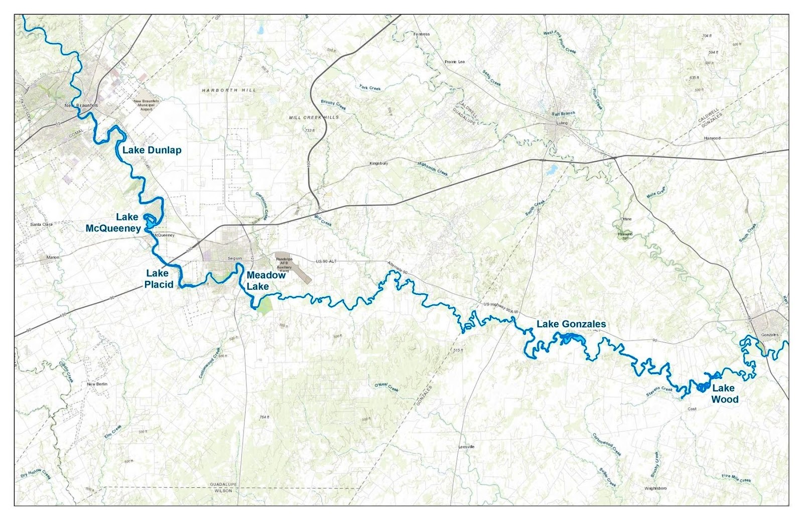
All the dams built to provide waterpower to milling operations were of modest height. However, around 1930 the government built five small dams on the Guadalupe River below New Braunfels to generate electricity. These were different, the base was made of concrete and each was equipped with generators and fitted with steel gates that could rotate open to release flood waters. This was a viable project then as the state was in between the eras of waterpower and power generated by fossil fuels.

Figure 5 Map showing location of five dams
These five dams created very small reservoirs that provided the height for generating power, but held very little water.

Figure 6 is a photo from the shoreline of Lake Gonzales showing the dam and powerhouse.


Figure 6 Lake Gonzales just above the dam

The trees on the right side of the photo are on the opposite shore of the lake, so this shows the smallness of the reservoirs. None stored much water as can be seen from the map of Figure 5, but all were equipped with electrical generating equipment. Starting from New Braunfels and going down river, there is Lake Dunlap, Lake McQueeney, Lake Placid, Lake Gonzalez and Lake Wood. These dams are now 90 years old and beginning to show signs of failure. Not total failure, but failure of the flood gates that are the upper part of the dam that is rotatable in order to be able to lower the height of the dam in case of river flooding. Lake Wood failed four years ago, and Lake Dunlap failed this past May.
This is what the Lake Wood Dam looks like from below. If you look at the facing of the concrete wall, by the powerhouse, you can see the outline of the upside-down vee shaped structure that formed the flood gate, which was never replaced after it failed.

Figure 7 Lake Wood Dam from below


The governing body of these lakes, the Guadalupe Blanco River Authority (GBRA) wants to lower the water level in all these dams because of the concern for failure of the floodgates of the other three. Today, since two of these dams have had their flood gates fail, the GBRA plan is to dewater the other three dams and inspect for safety issues. And, if truth be known, the GBRA would probably prefer to remove all the flood gates and thus decommission the dams. This is not a popular idea with those people who have homes on the shores of these reservoirs.
The electricity generated from these five dams is insignificant compared to total demand of the state; the value of the electricity generated does not cover the maintenance of the dam structure. The GBRA has little incentive to maintain the dams at their current level because, as they say, the current condition is a safety issue and the need for additional maintenance is required. The residents contend that the safety issue caused by sudden release of water is way overblown because the amount of water held by the dam’s flood gates if suddenly released is insignificant compared to normal flooding. Presently, the courts have issued an injunction which puts a hold on the emptying of the other three lakes for at least 12 months. The injunction also stipulates that the lakes will be closed to all surface activity beginning Thursday, September 19, 2019. A panel of 3 experts will be chosen; 1 from GBRA, 1 representing the plaintiffs and 1 chosen by both. The panel of 3 will have 30 days to determine what areas, if any, are safe for activity. The 30-day time period can be extended for another 30 days if needed. Professional law enforcement, acting as lake patrol, will be added to enforce the restrictions on each lake. After the failure of the Lake Placid floodgate, the water level of Lake Gonzales has been lowered two feet from normal which is where it stands today. The safety issue is more complex than described here, because one of the problems encountered by the GBRA is that after passing regulations that bar people from the dam structure area, recreational people flaunt these rules. No telling what will happen if people neglect to obey the rules set forth in the injunction.
Today, the only viable power generation on the Guadalupe River is Canyon Dam. In addition to power generation the dam is also used for flood control, recreation and storage of water which is then sold to cities and to rice farmers along the coast. Storage of water supplies for cities will dominate in the future and so, given the option, the reservoir will retain the water and not be discharged for electrical generation.
Waterpower in the area has become insignificant relative to the power consumed by the state, so it begs the question of how significant is our waterpower today compared to total demand? Just as an aside, let’s look at power generation in our state and compare it to all hydroelectric power and to the power available from the Guadalupe.
The available power from a river is easily calculated from water flow rates and the change in elevation. Obviously, when river flow rates decrease then power capability is diminished. Very roughly though, we calculate the Guadalupe River’s total potential is about 40,000 horsepower providing all the change in elevation from Kerrville to the Gulf is utilized and the water flow rate is “normal”. When that is considered, the potential power of the Guadalupe is equivalent to about one aircraft jet engine’s output when travelling at 400 mph. But even more dramatic, just one large natural gas turbine/steam turbine power generator can produce 15 times the power of the river. Thus, hydroelectric power has almost disappeared in the Lone Star State.
This graph shown as Figure 8 puts that in perspective.
Figure 8 Power sources in Texas 2017

The scale on this graph, given the size of some of the sources of power, hydroelectric power does not even get off the baseline.
We have chosen to end this article with a repurposed mill and power plant in Seguin on the Guadalupe River. The Seguin Mill was built on the Saffold Dam in the late 1800s for milling grain and ginning cotton, but then was converted by Henry Troell in 1894 to an electrical generating plant for the City of Seguin.
This transformation from a water powered mill of grains to an electrical generating station is a good example of changing times. Grain milling was probably in decline in the area and the opportunity to generate electricity prevailed.
Below is a photo of the dam and associated powerhouse where the electrical generator is located. From the photo, it appears that the horizontal underwater wheel turned the vertical shaft connected to the power unit.


Figure 9 Seguin Power Plant at Saffold Dam

This photo (Figure 9) shows the tall structure where the generator is located. It is in the tower at the upper end of the vertical shaft. Next, in Figure 10, is a picture of the generator located in the tower. It was driven by the upper end of the wheel shaft.


Figure 10 Generator at Seguin Power Plant

The limitation of waterpower, especially during low water flow, or the growing need in Seguin for electricity resulted in the addition of an auxiliary diesel engine for producing electricity. It is shown in Figure 11. This antique engine has four huge cylinders and operating at a low speed probably made a powerful sounding noise. It is still coupled to the generator, off to the right side, off the edge of the photo.


Figure 11 Busch Sulzer Diesel Engine 


Figure 12 Powerplant Texas Grill from across the river

The power plant building has been restored and now provides a pleasant setting for the Powerplant Texas Grill.

Sightings

The lack of rainfall has kept most opportunities for sightings depressed, but we did find some flowers not seen before by us when we visited the Guadalupe River dams. In other words, since the water did not come to us, we had to go to the water to see some plants not seen before.  Here in the water of the Guadalupe at Gonzales dam, we found these two plants growing in about  foot of water.  We have identified these two flowering water plants as labelled.
Figure 13 Water Hyacinth.  eichhornia crassipes

Figure 14  Mexican Primrose Willow  ludwigia octovalvis

Both these are probably hated plants because they are fast growers and invade bodies of water quite quickly.  However, there are only a  few plants that don't have at least one redeeming quality.  These two have good flowers, especially the hyacinth, plus, for all we know, these plants probably do some water purification as well.


Friday, September 13, 2019

Newsletter No. 20---Cotton


Cotton has been grown in Texas for 274 years since it was reported by Spanish missionaries in San Antonio in 1745.[1]  The several thousand pounds produced annually were then spun and woven on site.  And in 1813 nitrocellulose or gun cotton was used in explosives.  Anglo-Americans took up cotton cultivation in 1821 and the state reported production of 58,073 bales each weighing 500 pounds. 

Figure 1   Family Picking Cotton
Ferdinand Roemer[2] in 1846 tells of staying with a wealthy slave-owning planter who resided east of Caldwell.  He found it remarkable that in spite of his wealth, the family lived in a simple log home and ate very simply.  “And …though otherwise in agreement with his English cousin does not share with him the love for a comfortable and cozy home.”  The owner told him that he was planning to abandon the farm in spite of its prime location and buy farther down on the Brazos River because it cost him about $500 a year to get his cotton to the market in Houston.  Roemer noted that “The scarcity of easy communication …, is so general in most parts of Texas that it proves an obstacle in the development of the country”.

As everyone knows, Eli Whitney invented the cotton gin in 1794 in Georgia and patented it for use on short-staple cotton grown inland.  The long-staple cotton grown along the coast could easily be parted from its seeds, but the short-staple contained sticky, green seeds that were a problem to extricate.
Figure 2 Whitney's early cotton gin


A small gin could be hand cranked; larger versions could be harnessed to a horse or driven by waterpower. According to Whitney, “One man with a horse will do more than 50 men with the old hand cranked machines.”[3]

However, he and his partner made little money from the gins they produced as the farmers resented having to go to his gins and pay what they considered an exorbitant amount.  They began to pirate his gin designs, labeled them new and lawsuits against them were tied up in the courts for years.  Instead, Whitney later became rich by making and selling gin replacement parts and by becoming the father of mass production.  In 1798 he figured out how to manufacture muskets by machine, so the parts were interchangeable.  His work with the cotton gin also created the technology with which the North won the Civil War.

 The 1850s-60s saw a sharp increase in cotton production because of the removal of the Indians and opening of new land.  By 1852 Texas was number 8 of the top 10 cotton producing states.  The 1859 cotton census recorded 431,645 bales each weighing 500 pounds.  The number decreased during the Civil War, but by 1869 had moved up to 350,628 bales.  Railroads were built and stimulated the industry by making it easier to get the cotton to markets, so in 1879 some 2,178,435 acres produced 805,284 bales.  It continued to rise, and the 1900 crop was more than 3.5 million bales from 7,178,915 acres.

Locally, Edward Burleson bought a large tract of land in 1844[4] that included the headwaters of the San Marcos River.  He constructed the first dam on the river and the water from the spring powered his grist and sawmills.  After his death in 1851, the “Mill Tract” property supported many different businesses including a cotton gin. There is an historical sign in front of the Salt Grass Restaurant on Sessom Street.


Figure 3 the Burleson Mill Tract

In the 1850s the William Thompson family moved from Louisiana with their slaves to plantations in Hays and Caldwell counties.  With slave labor a mill was built on the San Marcos River which powered a cotton gin and lumber operation.  This area is known as Thompson’s Island and there is an historical marker near the intersection of Cape Road and River Road at:  Geo: 29.8674 -97.9315.

Figure 4  Thompsons Island, San Marcos River

Until the Civil War people in the area were mostly rural subsistence farmers according to Freeman Center.  At about the time of the Civil War the population in Hays County was a little over 1,000 people, one third of them Black slaves.  Cattle ranching was the main economic activity with corn the chief food crop along with small commercial crops of cotton. 

In 1868 Alexander Parkes created an interesting and unusual cotton byproduct by combining nitrocellulose (gun cotton) and camphor. Known by other names as well, it was registered as Celluloid in 1870.  Widely used in the 1800s and early 1900s, it was fashioned into pins, buttons, fountain pens, dolls and many other plastic-like items.

After the Civil War cotton production was aided by the growing web of railroads across the cotton producing areas.  And in 1872 the Blackland Prairies of Central Texas hosted thousands of immigrants from the Deep South and Europe.  Some bought small farms, but many worked as tenant farmers or sharecroppers for owners of as many as 6,000 acres.

 The tenants lived in houses furnished by the owner, but supplied their own draft animals, tools and seed for which they received two-thirds of the profit from the ginned cotton with one-third going to the owner.

The sharecroppers, with a different arrangement from tenant farmers, furnished only their labor while the landowner provided the houses, animals, tools and seed. The profit was split between both parties.

Both tenants and sharecroppers were expected to trade for all their needs at the landowner’s store where an account was kept of the purchases.  At the end of the season after they settled up, the laborers usually had little cash left over.  This socially enforced crop-lien system began after the Civil War and lasted until the 1930s causing debt peonage or economic slavery.

In 1873 an immigrant from Germany, Henry Schumacher, of Navasota, built another machine very important to the cotton industry.  Using the description from an old encyclopedia, he erected one of the first oil works that produced cottonseed oil, meal and cake.  This machine could process about 1500 tons of seed a year. Cotton seed oil was an instant success. Cotton seed oil is now used widely in the food industry. Schumacher was honored for his contributions to the cottonseed oil industry about 1883 with a dinner at the White House given by President Chester A. Arthur.  The first mill burned in 1910 but was rebuilt with all modern machinery and ran until 1954.[5]
Figure 5  Zedler's Mill in Luling, Texas

Built in 1874 on the San Marcos River, Zedler’s Mill is the same age as Luling and had been in the same family for more than 100 years.  The water-powered mill was used to saw lumber, grind corn, mill cotton and was the town’s first electric generator.[6] 

Zedler’s Mill is now a museum that is continually being enhanced.  We last visited it a few weeks ago in August and more displays had been added to the cotton, corn grinding and tool areas.  It sits on lovely grounds on Magnolia Street and is free and open to the public.  Access directions and hours on the Web.

Figure 6  Old Cotton Compress on rotating table in Zedler’s Mill.

The cotton bale on the left has been compressed, tied and is ready to be removed as more cotton comes down the chute on the right side to fill the compress. Once compressed and bound it would have been rotated out like the previous bale.

In 1884, Robert S. Munger of Mexia[7] revolutionized the “plantation method of ginning” by devising the faster, automated “system ginning” that we use today. Huge cotton compresses that reduced 500 lb. bales to about half their ginned size were built along railroad rights-of-way in many towns for convenient shipping.  This allowed farmers in interior cotton growing areas to sell their ginned cotton directly to buyers who shipped it directly to the mills.  Cotton could be sold on the world market via telegraphed contracts.  In addition to cotton fibers, cottonseed oil, and cattle feed from hulls, nitrocellulose to be made into celluloid was shipped as well.

The Lockhart Gin Co. that sits by the railroad tracks on Brazos Street could have been an example of that type of gin. In business for 113 years it began ginning this year’s crop of cotton on August 26.

In 1908 five local farmers purchased a site at 120 W. Grove Street in San Marcos (Geo: 29.8743,       -97.9411) and built the Farmer’s Union Gin Co.  It was established under the leadership of Oscar Calvin Smith.  It was the first industrial–sized plant in town and was vital to the town’s cotton industry.  The original gin house burned down and was replaced by the brick house in 1911, which remained in operation until 1966. 

Figure 7  Farmer’s Union Gin Company

Figure 8  Austin Cotton Yard by Will Beauchamp about 1910

During the 1890s the boll weevil made its way up from Mexico and was first discovered near Corpus Christi.  It wasn’t long before damage was noted in all the southern cotton-growing states.   Farmers used calcium arsenate dust to fight back and along with help from the USDA and Texas at A & M, demonstration farms and experiment stations worked the problem.

WWI stimulated cotton production, but afterward prices slumped, times were changing and sharecroppers, tenants and returning veterans began moving to the cities to work in factories.  Mechanization had begun to dominate the farms.[8]   “The landlords are saying… they wanted to farm all their lands with tractors…in Hall County Texas alone there will be moving from the farms here 420 tenant farmers with the average of 5 persons to the family it simply means that 2,100 men, women and children will be driven…from the only occupation which they have ever known.  Whither will they go?”   

Other economic factors were the federal government’s control program under the AAA (Agriculture Adjustment Act) which curtailed farm product, reduced export surpluses and raised prices.  Also affecting the industry were an increase in foreign production, new synthetic fibers, the tariff, the lack of a lint-processing industry in Texas and, WW II which brought a shortage of labor and disrupted commerce.

After the war another facet of the cotton industry came to the fore locally when in 1949 cottonseed companies, including the legendary Harper Seed Farm of Martindale, supplied a large percent of the pedigreed cottonseed produced in Texas.

Figure 9  Harper Seed Co., Martindale, Texas

The seed company and gin are still on site but are no longer in business.

Figure 10  Martindale gin on the San Marcos River

On Friday, August 23, we went to Lockhart and noticed several fields of cotton that looked close to being ready to strip.  Cotton farming goes on year-round in Texas starting with planting in January in the Rio Grande Valley.  And for the second year in a row Wesley Vanderpool delivered the first bale of cotton in the United States to the Willacy Co-op in Sebastian, Texas on Friday, June 21, 2019. The first bale of cotton has come from the Rio Grande Valley for the past 66 years.

South Texas including the Hill Country and Big Bend harvests cotton in late summer and early fall.  Rolling Plains (Central) and East Texas harvest in October and November. The High Plains, (Wichita Falls, Amarillo} with the highest concentration harvest in December and early January near the planting time in the Valley.


Figure 11 Production in bales.
As can be seen in the above map, the High Plains area centered near Lubbock now grows most of the cotton in the state.  And the town of Spearman up toward the border of Oklahoma on Hwy 207 is home to the largest cotton gin in the U.S. and soon to be of the world.

Figure 12  2018 Cotton production in the U.S.
The huge irrigated fields of the Panhandle are conducive to the use of huge machinery; stripper/balers or stripper/lint trailers that dump into compressor/module makers that are picked up by trucks that can haul the 8’x8’x32’ cotton modules.

Figure 13  Cotton stripper/baler

Figure 14  Module hauler

This photo was taken in the yard of the Lockhart Gin Co.  The truck backs up to the leading edge of the cotton module in the field and a moving cog belt on the truck’s floor is engaged that hauls the module into the truck which then heads for the gin.

Figure 15  Lockhart Gin Company

We spoke to Roland at the gin and had been invited back for a tour later when they weren’t so busy getting the season started.  We returned on September 6 to see what we could see.  Following are some pictures R took of the proceedings.

Figure 16  Roland arrives from the field with 2 mini modules: 8"x8"x16'.

The moving track inside the truck is engaged and the module moves out onto the gin’s belt.  Each mini module weighs about 20,000 pounds. The truck carries two of these mini modules.

Figure 17  The modules are on their way into the gin.

First, they are torn apart and enter air conveying systems to dryers and cleaners where all the field trash is separated from the lint.  Then the cleaned lint is conveyed to the Cherokee 174 gin stand where the lint is torn free from the seeds.  It is then blown on to an additional cleaner and then on to the compress where the lint is compressed into 500-pound bales, strapped and wrapped bales.  From beginning to end the farmer’s number is marked on his cotton with a serial number and barcode.  A sample is taken of his cotton which is sent to Corpus Christi where it is graded.  This is how the farmer finds out how much he can charge for his cotton.

Figure 18  500-pound bales of wrapped cotton exiting the gin.

A forklift fitted with a bale lifter moves the bales from the platform to the barn.  The barn is shown below.
Figure 19  Sal is leaving the barn for Taylor loaded with 100 five hundred-pound bales of cotton.

At the intersections of the Missouri Pacific and Missouri, Kansas and Texas lines and State Highway 95 and U.S. Highway 79 Taylor, Texas has been the shipping point for Central Texas cotton since the early 1900s.  In just a little over 2 hours, Sal will be back for another load of cotton.

And thus begins another year of cotton production in Texas. 


_____Sightings

Native plants that get all the raves this time of the year are the ones that can produce flowers with our droughty conditions.   Here are five:
Figure 20   Skeleton Plant

Figure 21  Silver Leafed Nightshade


Figure 22    Lindheimer’s Senna


Figure 23   Retama

Figure 24  Zexmenia

Despite their willingness to bloom in this dry period, they all would prefer a bit more water.


[1] Texas State Historical Association’s (THSA) “Cotton Culture”.
[2] Roemer’s Texas 1845 to 1847 by Dr. Ferdinand Roemer
[3] National Archives, Educator Resourses.
[4] Texas State University Archives
[5] Texas Historical Marker
[6] F.N. Day Trips column by Gerald E. Mcleod, Apr. 14, 2006 The Austin Chronicle.
[7] THSA Cotton Culture
[8] Jerry Pytlak-The New International Vol. 5 No. * Aug. 1939 pp. 247-250.

Wow! 2024 A year of change

 Looking back over my notes of what happened with the vegetation this year brought back memories of how much of a shift we have seen from pa...