Prior
to 2011, there was a large area of Loblolly Pines growing in an unlikely spot
in Central Texas. Unlikely because in
travelling from the vast forests of east Texas and Louisiana westward, one finds miles and miles of
rolling prairie until just before entering the Hill Country where there are
these large, towering pines. Centuries
old, this pine forest is called The Lost Pines. The “lost” name was applied
because this forest was a remnant, disjunct section of pines that was separated
from their species in East Texas by about 100 miles. This 100,000-acre forest became
disconnected from the same species of tree of the well- known Piney Woods of
East Texas during the most recent glacial period of the Pleistocene era. Interestingly, from the botanical detail of
the two stands of Loblolly Pine, it may be that the Piney Woods tree is an
offshoot survivor of the Lost Pines trees.
That might be true, but what is evident is that the soil is key to the
existence of these pines in the Bastrop area.
The soil is red sandstone, and the pines liked it such that they stayed
after the last glacial age ended. Some
recent studies show, however, that the Bastrop pines are slowly giving up their
residency in this area of Texas. Left
alone, they may slowly disappear in another couple thousand years.
Early
botanists noticed this pine forest as unusual. It was mentioned nearly 174
years ago in June of 1846 by Ferdinand Roemer[1]
as he and a friend were travelling from LaGrange to Bastrop. As he approached the area, he noted the
sandy, gravelly soil with pieces of petrified wood, and made note of the Loblolly Pine and Post
Oaks. To quote from his journal: “Just
opposite La Grange, the peculiar sterile, salacious soil appeared red in which
in addition to red rubble stones, larger and smaller pieces of silicified wood
occurred very frequently. Only post oak
(Quercus obtusiloba) and yellow pine (Pinus taeda L.) grow on the long
stretches of gravel and sand of Central Texas.
Both
species of trees have the peculiarity of excluding all other trees where they
grow whereas other deciduous forests of North America are composed of a variety
of trees.
In
distinct contrast, to the prevailing uniformity of the vegetation and sterility
of the soil, stood the forested bottoms of
several brooks flowing into the Colorado River through which our way
led. In this deep black soil, the bottom
vegetation grew as luxuriantly as is the case along the larger rivers such as
the Brazos. The huge Poplar trees on which the grapes and other vines climbed,
were again conspicuous.”
Logging
of these big pines in the 1800s reduced the population of trees by about ten
percent for the wood required to build homes and commercial buildings. Then, a
large area was protected by the two state parks established nearly a hundred
years ago. Bastrop State Park and Buescher State Park have always been popular
places for recreation.
Fires
have always been a threat in pine forests and that came into play when on an
extremely hot and windy day, the sparks from a downed power line in two
locations ignited the brush and tree debris and an out-of-control ground fire
was started. Quickly, the ground fire
became hot enough and so intense that the fire got up into the treetops and
began to consume the whole area. The fire of September and October 2011 lasted
for weeks and threatened the whole area.
To
understand how this fire went from a ground fire to a forest destroying fire,
it’s important to understand pine rosin.
Normally, fire control experts who manage controlled burns will easily
agree that pines of this size, some of them 2 feet in diameter, can withstand
intense fire around their base. But, let
that fire get into dense underbrush and grow to such a size that it reaches the
green needles of the tops of the pines and its sure death to the tree.
We
experienced this problem with Ashe Juniper in Bandera County when a fire got
out of control some miles south of our property and burned a swath for miles
before being extinguished. The risk of a
small fire getting out of control depends on heat and dryness. When the foliage of evergreens such as
juniper or these Loblolly Pines experience ambient temperatures above about 110
degrees F, the rosin in the needles can burst into flames from even the
smallest ignition sources. That was the
problem in Bandera and it appears the same risk factor situation that existed
in the Bastrop area when this fire got out of control. That is, the fire reached into the needle
foliage of the upper part of the tree and then raced from tree to tree until it
essentially ran out of trees.
34,000
acres, nearly half of this grand old forest in Bastrop County, were ruined; 1,660
homes were destroyed; 2 people perished and 12 were injured. Both state parks were damaged. That was 9 years ago, and the appearance of
the area still shows what a terror this fire must have been.

At first, the
speculation was that carelessly tended open fires were the cause of the fire,
but weeks later in probing the starting areas, it was concluded that in two
places, power lines were broken by the wind and fell to ground causing
sparks. We always generate a lot of
worry about pipeline hazards, but never worry about power line failures, but
now that has changed.
The fire was
observable for miles, traffic was detoured, and emergency crews arrived from
all over the state and even from other states.
As is the case with
all intense fires like this, the fire created its own windy condition, adding
to the normal windy condition at the time.
This made firefighting difficult and
remarkably ineffective.

From
Figure 28.2 it should seem obvious that the flames during the height of the
fire were way above the tops of the trees, making it easy for the fire to run
high off the ground consuming all the forest in its path.

Figure 28.3 Aerial view of scorched area
Figure 28.3 is an aerial view of the burned swath through the forest. It was a very windy day and quite easy to imagine the wind-driven fire raging through this area. The topography is not all flat as it looks on the right in the picture but is in many places hilly and cut with many ravines. In some areas of the burned part, there are towering hulks of the dead trees. However, for most of the area, the trees that died have been cut down, and, we think used for good purposes, as the felled tree if not hauled away would be visible and they were not.
We visited the area this past winter to see how well the forest was recovering from the fire. Here is what we found.

Figure 28.4 The first stop on our tour
It was also a warm
day and the redolent breeze carried the fragrance of pine needles. In the
distance under the new growth of replanted loblollies a rust-colored carpet of
old needles could be seen.

Figure 28.5 New growth appearing

Figure
28.6 Example of the Loblolly Pine bark
Before
moving on to see the rest of Bastrop Park, we we took Road 1B to check out the
Pioneer Village Cabin Area.
The trees in this immediate area were not affected. These cabins were all constructed and built
by the CCC in the 1930s using the pine logs of the area. Here is just one of about twenty cabins in this
village and several of them were occupied on the day of our visit. The tree at the left of the cabin is typical
of the mature trees in this forest.

Figure 28.7 CCC
built cabin in Bastrop Park

Figure 28.8 Much of the forest didn’t survive
There are still grim reminders of the devastation and visitors are warned to stay away from standing dead trees because they may topple over. Continuing on Road 1A on our way to the Overlook, we noticed a few spots of what looked like possible prescribed fires along the sides of the roads.
In an unrelated incident to the fire, that same year on Memorial Day, heavy rains caused the already full Bastrop State Park 10 acre lake dam to fail and the flooded Copperas Creek surged down the ravine on a wild tear to the Colorado River. Its waters damaged roads, trails and the golf course. The Texas State Legislature has appropriated 8.4 million dollars for repairs but it is all taking time. Arriving at the overlook situated on a prominent knob, we took pictures across the ravine shown in the foreground of Figures 9 and 10. The ten-acre lake once filled this ravine. Presently there is no water.

Figure 28.9 Barracks with the telephoto lens.
Figure 28.9 also
shows new pine growth that is emerging all over the burned area. The appearance of the new pine growth shows
that seedlings began to emerge right after the fire, because most of the young
pines are 8 years old based on their growth sections. There is some on-purpose reforestation
occurring in certain areas.
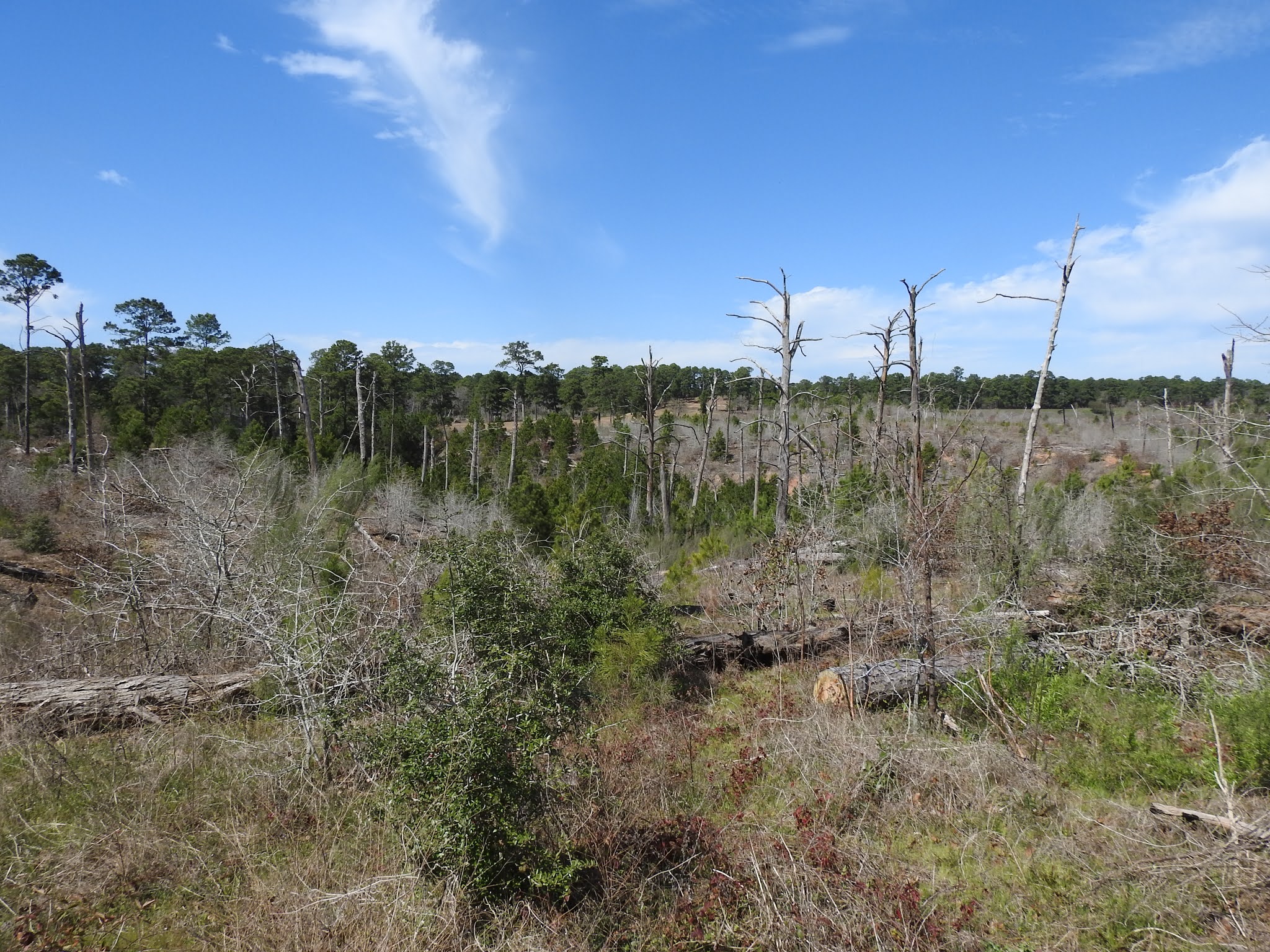
Figure 28.10 Barracks and other buildings with the regular
lens.
It will be
interesting to observe how this area recovers in the next twenty years because
there appears to be competition from the hardwoods. For this pine forest to recover to its
original condition, the pines will have to dominate the hardwoods and even
drive them out. Presently the score is
even in most of the recovering areas.
The Bastrop County
Complex Fire was the most devastating wildfire in Texas’ history and in
searching the Internet for ideas to prevent recurring fires, we came upon an
article by FEMA that outlined some steps to protect residents. One action the county is taking, according to
Mike Fisher, Bastrop County’s Office of Emergency Management Coordinator, is
fuel reduction. Ridding the understory
of dead trees, fallen trees and unwanted understory growth by mulching as
opposed to prescribed burning is nontraditional and labor intensive, but Fisher
says it’s one that‘s unique and not been
used before as far as he can tell.
The county received a grant from FEMA’s Hazard
Mitigation Grant Program (HMGP) to fund the program. Almost 4,000 acres were targeted and placed
into north and south zones. The zones
were studied to determine where large tracts of wild land (with a history of
destructive fires and high- density understory fuel) met smaller tracts of
developed land and subdivisions or houses located on small, medium and large
lots (with varying degrees of fire resistivity and defensible space). FEMA contributed over $1.2 million of the $1.6
million cost of the north project and $1.6 million of the $2.1 million cost of
the south project . The HMGP grant had a
two-year performance period. Four skid
steer tractors were purchased with these grant funds and will be used to clear
the understory. Also, another idea to
clear 1000 feet each side of 1441 was proposed.
Using the skid
steers, low-impact machines with a mulching head on the front, the county
designed a mechanical thinning process.
Operators grind up the understory and remove undesirable tree species
growing under the tree canopy. On a wildfire
outbreak the fire stays on the ground and does not go into the trees.

Fisher found few skilled contractors available to work the machines so county employees learned how to operate the equipment and will proceed with the task of clearing.
The
project sparked excitement, curiosity, and some reservations among residents in
most of the private acreage targeted for mitigation. Fisher found “getting the residents buy-in
the most challenging part of the project,” but “believes what the county is
doing is a good measure to take.”
To
get another professional opinion on what has happened since 2011, we contacted
Kari Hines, Firewise Coordinator Mitigation and Prevention Department Texas A
& M Forest Service in LaGrange. Kari
said that in late 2015 or early 2016 was when the crews began the mulching
project and the first phase was accomplished in Tahitian Village. There were two human-caused fires in 2016,
that she knew about, in areas that were treated that the local fire department
was able to put out more quickly and safely because of the work that was
done. Work was done almost completely on
private property, with the agreement signed by the landowners that they would
be responsible for maintaining the low fuel condition after the work was done. Future phases of this work included mulching
on the Boy Scout Camp and private property along 1441 and further south, in and
around some developed neighborhoods between Bastrop and Rosanky. Today, one can see in Tahitian Village and on
1441 which owners allowed mulching, and which didn’t by the density of the
understory vegetation. Depending on
maintenance, the yaupon has grown back quite well in some areas. Owners could decide how the mulching was to
be carried out so there is often a mosaic pattern to the work completed on
their properties.
Kari
went on to describe other efforts on public lands by Texas Parks and Wildlife,
Texas A&M Forest Service, Texas Military Division (Camp Swift) and other
large- scale landowners including and expanding their forest floor fuel
reduction projects. These were projects
that had been in place before the 2011 fire and were accomplished by hand with
chain saws, mulching equipment, or prescribed fire. The Bastrop Complex showed land managers how
important proper land management is as
it was obvious that stands of trees that had prescribed fire in Bastrop State
Park had much less severe damage than adjacent stands where prescribed fire had
not been applied in years.
With our membership in Firewise we are reminded of the dangers of the growth of
ladder fuels around our homes. Our
website features a Firewise newsletter on the effectiveness of fire damage
prevention. To maintain our rating of a
Firewise Community, we complete a report annually and submit it to the Forest
Service. So, when you are out and about,
survey your property, especially the area close to buildings and if you do any
clearing on your property that can’t be seen from the road, please let us know
so we can include it in the report.
____________Sightings
§ This
month the main sighting has been rain.
Wiley’s data posted on the website from his official rain gauge showed
that we received 4.5 inches on Tuesday the 12th.
§ We
have not seen the Poor Will nor the Cuckoo but have heard these two annual
residents already. These are two birds
that are usually never seen but often heard calling.
§ What
is somewhat disappointing is that we have heard nothing of the Bobwhite
Quail. We hope that someone has heard
them indicating that these birds are still here. There is no telling what damage to wildlife
and plant life has occurred because of the drought of last summer.
R &D
Tusch


